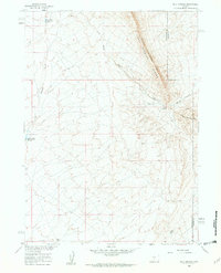
1960 Map of Bull Springs
USGS Topo · Published 1962About this map
The Lost Soldier Divide dominates this portion of the Wyoming high desert, marking a sharp topographic boundary between the northern and southern drainage basins. Surveyed as part of the Missouri River Basin development program, the landscape is defined by intermittent water sources and technical water management. Significant infrastructure is evident at the Upper Water Stewart Creek Reservoir and Lower Water Stewart Creek Reservoir, which capture the seasonal flows of Stewart Creek. Along the eastern edge of the quadrangle, the Sweetwater and Carbon county line traverses the ridge of the divide. The presence of Bull Springs and Coyote Spring beneath the Coyote Springs Rim highlights the critical importance of these rare permanent water points for livestock and wildlife in a region otherwise characterized by dry washes like Bulls Creek.
Find a feature on this map
11 named features on this map. Tap any name to fly to it.
Don’t see what you’re looking for? This feature index may not catch every label — zoom into the map to look around manually.
Map Details
Editions of this 1960 Bull Springs Map
3 editions found
Other maps of this area

1954 · Rawlins
USGS Topo · 1:250,000

1955 · Casper
USGS Topo · 1:250,000

1956 · Rawlins Peak
USGS Topo · 1:62,500

1958 · Rawlins
USGS Topo · 1:250,000

1958 · Casper
USGS Topo · 1:250,000

1960 · Larsen Knoll
USGS Topo · 1:24,000

1960 · Separation Rim
USGS Topo · 1:24,000

1960 · Bull Springs
USGS Topo · 1:24,000

1960 · Buck Draw
USGS Topo · 1:24,000

1960 · Chicken Spring
USGS Topo · 1:24,000