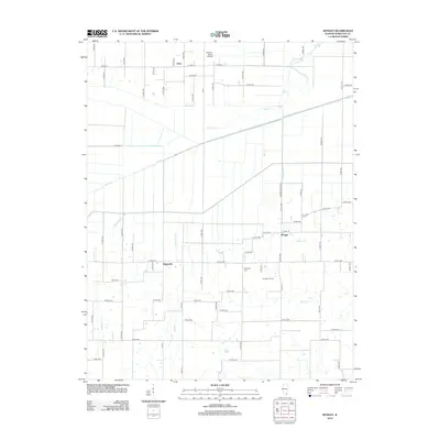
2012 Map of Bungay
USGS Topo · Published 2012About this map
Blairsville and Bungay anchor this agricultural landscape in Hamilton County, Illinois, where the rural grid is defined by a dense network of county roads. The area is characterized by its drainage patterns, with Big Creek and Haw Creek cutting across the northern half, while Wolf Cr Drain and Beaver Cr manage the southern fields. A notable industrial presence is seen at the Bungay Oil Field, indicating the region's intersection of traditional farming and resource extraction. For those researching local family history, Springer Cem is located near the center of the sheet, and the Moulton Farms Airport provides a specific point of interest in the northern section near Aden. The terrain is predominantly flat, typical of the Southern Illinois prairie, with small woodlots concentrated along the winding paths of Ferguson Creek and its tributaries.
Find a feature on this map
59 named features on this map. Tap any name to fly to it.
Don’t see what you’re looking for? This feature index may not catch every label — zoom into the map to look around manually.
Map Details
Editions of this 2012 Bungay Map
This is the sole edition of this map. No revisions or reprints were ever made.
Other maps of this area

1941 · Enfield
USGS Topo · 1:62,500

1942 · McLeansboro
USGS Topo · 1:62,500

1944 · Enfield
USGS Topo · 1:62,500

1945 · McLeansboro
USGS Topo · 1:62,500

1947 · Wayne City
USGS Topo · 1:62,500

1948 · Fairfield
USGS Topo · 1:62,500

1958 · Belleville
USGS Topo · 1:250,000

1962 · Belleville
USGS Topo · 1:250,000
1971 · Boyleston
USGS Topo · 1:24,000
1971 · Burnt Prairie
USGS Topo · 1:24,000