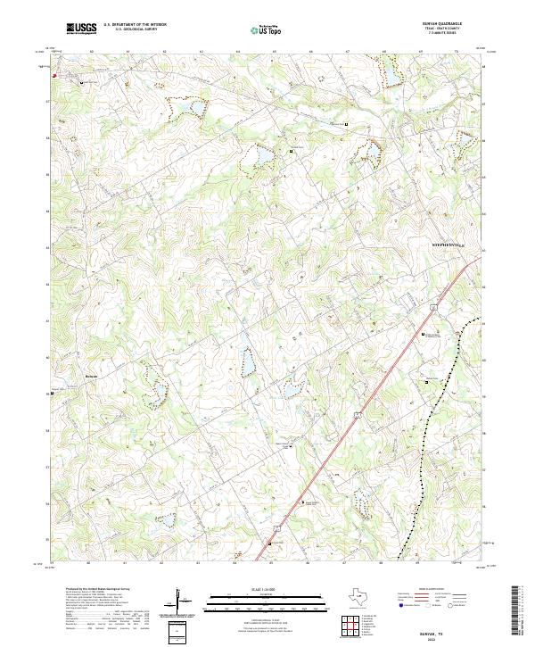
2022 Map of Bunyan
USGS Topo · Published 2022About this map
Bunyan sits amidst a landscape of winding creeks and family burial grounds in this Erath County study. The rural character of the area is defined by its numerous historic cemeteries, including Upper Green Creek Cem and Lower Greens Creek Cem, which speak to long-standing community roots along the local waterways. Water management is a visible priority across the terrain, with features like Kiker Lake, Bates Lake, and Huckabee Lake serving the surrounding agricultural lands. Toward the eastern edge, the growth of Stephenville begins to emerge along Alarm Cr, where more modern developments like Erath Gardens of Memory Cem are situated. The map captures the transition from the secluded settlement of Bunyan to the more developed corridors near the county seat.
Find a feature on this map
96 named features on this map. Tap any name to fly to it.
Don’t see what you’re looking for? This feature index may not catch every label — zoom into the map to look around manually.
Map Details
Editions of this 2022 Bunyan Map
This is the sole edition of this map. No revisions or reprints were ever made.
Other maps of this area

1890 · Stephenville
USGS Topo · 1:125,000

1920 · Stephenville
USGS Topo · 1:125,000

1954 · Abilene
USGS Topo · 1:250,000

1958 · Abilene
USGS Topo · 1:250,000
1961 · Alexander
USGS Topo · 1:24,000

1961 · Knob Hill
USGS Topo · 1:24,000

1961 · Stephenville
USGS Topo · 1:24,000

1965 · Huckabay SW
USGS Topo · 1:24,000

1965 · Lingleville
USGS Topo · 1:24,000
1965 · Dublin
USGS Topo · 1:24,000