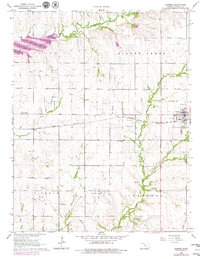
1964 Map of Burden
USGS Topo · Published 1979About this map
The town of Burden serves as the focal point of this Cowley County landscape, situated where the Atchison Topeka and Santa Fe railroad tracks meet the local grid. This 1964 survey, revised with mid-1970s data, reveals a region defined by its natural drainage and its subsurface wealth. A dense network of petroleum production is visible across the townships, from the Shannon Oil Field in the west to the Bolack Oil Field in the south, punctuated by scattered oil wells and a northern Quarry.
Find a feature on this map
30 named features on this map. Tap any name to fly to it.
Don’t see what you’re looking for? This feature index may not catch every label — zoom into the map to look around manually.
Map Details
Editions of this 1964 Burden Map
3 editions found
Other maps of this area

1889 · Burden
USGS Topo · 1:125,000

1955 · Wichita
USGS Topo · 1:250,000

1958 · Wichita
USGS Topo · 1:250,000

1962 · Dexter
USGS Topo · 1:24,000

1962 · Cambridge
USGS Topo · 1:24,000

1964 · Cambridge NW
USGS Topo · 1:24,000

1964 · Burden
USGS Topo · 1:24,000
1964 · Atlanta
USGS Topo · 1:24,000

1965 · Eaton
USGS Topo · 1:24,000

1965 · Winfield
USGS Topo · 1:24,000