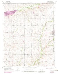
1964 Map of Burden
USGS Topo · Published 1983About this map
The community of Burden serves as the focal point of this mid-1960s Cowley County survey, situated at the junction of the Atchison Topeka and Santa Fe railroad and the local road network. The landscape is heavily defined by its subterranean resources, evidenced by the proliferation of named petroleum tracts such as the Frog Hollow East Oil Field, Turner North Oil Field, and Burden Oil Field. These industrial sites are interspersed with the agricultural and civic markers of the era, including the Fairgrounds on the eastern edge of town and several scattered rural burial grounds like Silver Creek Cem and Tisdale Cem. Hydrology is dominated by Timber Creek Lake in the northwest and the winding paths of Silver Creek and Plum Creek, which navigate the region's undulating prairie terrain.
Find a feature on this map
32 named features on this map. Tap any name to fly to it.
Don’t see what you’re looking for? This feature index may not catch every label — zoom into the map to look around manually.
Map Details
Editions of this 1964 Burden Map
3 editions found
Other maps of this area

1889 · Burden
USGS Topo · 1:125,000

1955 · Wichita
USGS Topo · 1:250,000

1958 · Wichita
USGS Topo · 1:250,000

1962 · Dexter
USGS Topo · 1:24,000

1962 · Cambridge
USGS Topo · 1:24,000

1964 · Cambridge NW
USGS Topo · 1:24,000

1964 · Burden
USGS Topo · 1:24,000
1964 · Atlanta
USGS Topo · 1:24,000

1965 · Eaton
USGS Topo · 1:24,000

1965 · Winfield
USGS Topo · 1:24,000