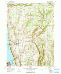
1950 Map of Burdett
USGS Topo · Published 1990About this map
Seneca Lake defines the western edge of this landscape, where steep ravines and points like Glen Eldridge Point mark the transition from the deep glacial water to the high upland plateaus. The topography is dominated by massive north-south ridges such as Satterly Hill and Burnt Hill, which are deeply incised by drainages like Texas Hollow and Excelsior Glen. In the south, the major regional center of Watkins Glen sits at the foot of the lake, showing its rail-and-water industrial footprint via the Barge Canal and the Pennsylvania railroad line.
Find a feature on this map
40 named features on this map. Tap any name to fly to it.
Don’t see what you’re looking for? This feature index may not catch every label — zoom into the map to look around manually.
Map Details
Editions of this 1950 Burdett Map
4 editions found
Other maps of this area

1893 · Ithaca
USGS Topo · 1:62,500

1895 · Ithaca
USGS Topo · 1:62,500

1898 · Watkins Glen
USGS Topo · 1:62,500

1901 · Watkins
USGS Topo · 1:62,500

1902 · Genoa
USGS Topo · 1:62,500

1902 · Ovid
USGS Topo · 1:62,500

1905 · Watkins Glen
USGS Topo · 1:125,000

1942 · Dundee
USGS Topo · 1:24,000

1942 · Lodi
USGS Topo · 1:24,000

1942 · Trumansburg
USGS Topo · 1:24,000