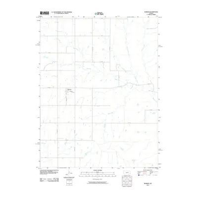
2010 Map of Burdick
USGS Topo · Published 2010About this map
Burdick serves as the central hub of this agricultural landscape in Morris County, with its small grid of streets including Anderson St and 2750 Rd surrounded by an expansive network of prairie drainage. The area is defined by a dense system of seasonal and perennial waterways that carve through the section lines, most notably Sixmile Creek and Diamond Creek. The naming convention of the local hydrography, such as Threemile Creek and Mile-and-a-Half Creek, suggests a landscape historically understood through the distance and travel times between water sources.
Find a feature on this map
26 named features on this map. Tap any name to fly to it.
Don’t see what you’re looking for? This feature index may not catch every label — zoom into the map to look around manually.
Map Details
Editions of this 2010 Burdick Map
This is the sole edition of this map. No revisions or reprints were ever made.
Other maps of this area

1889 · Parkerville
USGS Topo · 1:125,000

1894 · Parkerville
USGS Topo · 1:125,000

1898 · Cottonwood Falls
USGS Topo · 1:125,000

1955 · Hutchinson
USGS Topo · 1:250,000

1957 · Hymer
USGS Topo · 1:24,000

1959 · Hutchinson
USGS Topo · 1:250,000

1970 · Lincolnville NE
USGS Topo · 1:24,000
1971 · Lincolnville
USGS Topo · 1:24,000

1972 · Wilsey
USGS Topo · 1:24,000
1972 · Burdick
USGS Topo · 1:24,000