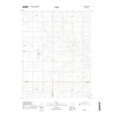
2018 Map of Burdick
USGS Topo · Published 2018About this map
Burdick serves as the focal point for this section of the Kansas prairie, situated at the intersection of Main St and BB Ave. The local landscape is defined by the convergence of several waterways, including Sixmile Cr, Threemile Cr, and the notably named Mile-and-a-Half Cr. For those researching family history or local heritage, the map identifies two significant sites: Hebron Lutheran Church Cem and Burdick United Methodist Cem, both located near the primary settlement. The terrain transitions across county lines, marking the borders between Morris, Marion, and Chase counties. The area's hydrology is further characterized by Diamond Spring and the winding paths of Camp Cr and Mulberry Cr, illustrating the drainage patterns that have shaped agricultural life in this region of the Flint Hills.
Find a feature on this map
46 named features on this map. Tap any name to fly to it.
Don’t see what you’re looking for? This feature index may not catch every label — zoom into the map to look around manually.
Map Details
Editions of this 2018 Burdick Map
This is the sole edition of this map. No revisions or reprints were ever made.
Other maps of this area

1889 · Parkerville
USGS Topo · 1:125,000

1894 · Parkerville
USGS Topo · 1:125,000

1898 · Cottonwood Falls
USGS Topo · 1:125,000

1955 · Hutchinson
USGS Topo · 1:250,000

1957 · Hymer
USGS Topo · 1:24,000

1959 · Hutchinson
USGS Topo · 1:250,000

1970 · Lincolnville NE
USGS Topo · 1:24,000
1971 · Lincolnville
USGS Topo · 1:24,000

1972 · Wilsey
USGS Topo · 1:24,000
1972 · Burdick
USGS Topo · 1:24,000