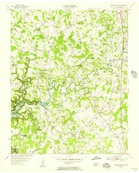
1956 Map of Burgess Falls
USGS Topo · Published 1957About this map
The Falling Water River carves a winding path through the borderlands of Putnam Co and White Co, defining the local landscape in the mid-1950s. This era shows the early influence of the Center Hill Reservoir and the containment of Burgess Falls Lake along the river's descent. The map captures a high density of rural institutions, particularly schools and churches that served as community anchors for outlying families. Notable landmarks such as Taylors Seminary, Elder Ridge Sch, and Bussell Sch suggest a dispersed but structured rural education network, while crossroads like Bakers Crossroads and Hamptons Crossroads served as primary nodes for commerce and travel. Genealogists will find significant value in the numerous family-named burial grounds, including the Hitchcock Cem, Howell Cem, and Harris Cem, which anchor the history of long-standing residents to specific acreage across Tidwell Hollow and the surrounding plateaus.
Find a feature on this map
42 named features on this map. Tap any name to fly to it.
Don’t see what you’re looking for? This feature index may not catch every label — zoom into the map to look around manually.
Map Details
Editions of this 1956 Burgess Falls Map
4 editions found
Other maps of this area

1892 · Pikeville
USGS Topo · 1:125,000

1893 · Mc Minnville
USGS Topo · 1:125,000

1895 · Mc Minnville
USGS Topo · 1:125,000

1895 · Pikeville
USGS Topo · 1:125,000

1897 · Standingstone
USGS Topo · 1:125,000

1898 · Standingstone
USGS Topo · 1:125,000

1943 · Cookeville
USGS Topo · 1:100,000

1944 · Cookeville
USGS Topo · 1:100,000

1953 · Chattanooga
USGS Topo · 1:250,000

1953 · Cookeville East
USGS Topo · 1:24,000