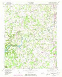
1956 Map of Burgess Falls
USGS Topo · Published 1980About this map
Falling Water River carves a winding path through the borderlands of Putnam and White Counties, defining the rural landscape of middle Tennessee during the mid-twentieth century. The river system, including Burgess Falls Lake and the nearby Center Hill Lake, anchors a region characterized by small-scale crossroads settlements and a dense network of country schools and churches. Prominent local landmarks such as Taylors Seminary and Almyra Sch reflect the educational history of the upland terrain, while numerous family cemeteries like Hitchcock Cem and Elrod Cem provide valuable touchpoints for genealogical research.
Find a feature on this map
47 named features on this map. Tap any name to fly to it.
Don’t see what you’re looking for? This feature index may not catch every label — zoom into the map to look around manually.
Map Details
Editions of this 1956 Burgess Falls Map
4 editions found
Other maps of this area

1892 · Pikeville
USGS Topo · 1:125,000

1893 · Mc Minnville
USGS Topo · 1:125,000

1895 · Mc Minnville
USGS Topo · 1:125,000

1895 · Pikeville
USGS Topo · 1:125,000

1897 · Standingstone
USGS Topo · 1:125,000

1898 · Standingstone
USGS Topo · 1:125,000

1943 · Cookeville
USGS Topo · 1:100,000

1944 · Cookeville
USGS Topo · 1:100,000

1953 · Chattanooga
USGS Topo · 1:250,000

1953 · Cookeville East
USGS Topo · 1:24,000