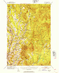
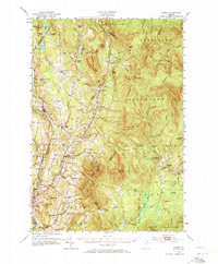
1951 Map of Burke
USGS Topo · Published 1953About this map
Burke Mountain and the surrounding Darling State Forest Park dominate the landscape of the Northeast Kingdom in this mid-century survey. The area is defined by a dense network of small rural schools such as Packer Sch, Marshall Sch, and White Sch, reflecting a time when isolated hill communities remained the backbone of the region. The Canadian Pacific railroad cuts through the western edge, connecting settlements like West Burke and Lyndonville to the larger markets of the north and south.
Find a feature on this map
136 named features on this map. Tap any name to fly to it.
Don’t see what you’re looking for? This feature index may not catch every label — zoom into the map to look around manually.
Map Details
Editions of this 1951 Burke Map
6 editions found

Other maps of this area

1900 · Whitefield
USGS Topo · 1:62,500

1919 · Lake Memphremagog
USGS Topo · 1:62,500

1920 · Derby
USGS Topo · 1:62,500

1920 · Guildhall
USGS Topo · 1:62,500

1923 · Lake Memphremagog
USGS Topo · 1:48,000

1924 · Island Pond
USGS Topo · 1:48,000

1925 · Memphremagog
USGS Topo · 1:62,500

1926 · Island Pond
USGS Topo · 1:62,500

1929 · Averill
USGS Topo · 1:62,500

1931 · Guildhall
USGS Topo · 1:48,000