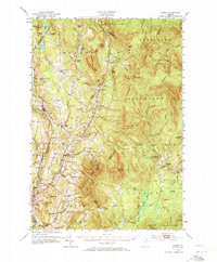
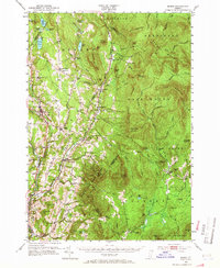
1951 Map of Burke
USGS Topo · Published 1973About this map
Darling State Forest Park dominates the southern landscape, where Burke Mountain rises above the transition from timbered ridges to river valley farming. This early 1950s survey documents the Northeast Kingdom's rural infrastructure, featuring a dense network of local district schools like Newark Street Sch and Bundy Sch. The drainage of the Passumpsic River and the Moose River defines the settlement patterns of West Burke and Gallup Mills, while the Canadian Pacific railroad cuts through the western edge of the quadrangle. Genealogists will find numerous small burial grounds, including the Victory Hill Cem and Burke Green Cem. The topography is defined by the East Haven Range, with isolated spots like Lost Nation reflecting the region's character. High-altitude landmarks such as the Ski Jump and Ski Tow on Burke Mountain point to the area's emerging recreation economy.
Find a feature on this map
137 named features on this map. Tap any name to fly to it.
Don’t see what you’re looking for? This feature index may not catch every label — zoom into the map to look around manually.
Map Details
Editions of this 1951 Burke Map
6 editions found

Other maps of this area

1900 · Whitefield
USGS Topo · 1:62,500

1919 · Lake Memphremagog
USGS Topo · 1:62,500

1920 · Derby
USGS Topo · 1:62,500

1920 · Guildhall
USGS Topo · 1:62,500

1923 · Lake Memphremagog
USGS Topo · 1:48,000

1924 · Island Pond
USGS Topo · 1:48,000

1925 · Memphremagog
USGS Topo · 1:62,500

1926 · Island Pond
USGS Topo · 1:62,500

1929 · Averill
USGS Topo · 1:62,500

1931 · Guildhall
USGS Topo · 1:48,000