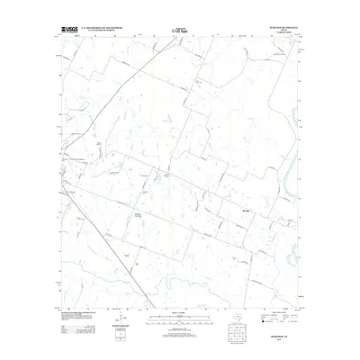
2013 Map of Burleigh
USGS Topo · Published 2013About this map
The Brazos River defines the eastern boundary of this Southeast Texas landscape, where a dense network of country roads connects family settlements and historic community centers. The Coshatte Agricultural Society Hall serves as a central landmark for the area, reflecting the region's agricultural heritage alongside the nearby Coshatte Cem. Further north, the Racoon Bend Oil Field indicates the local extraction industry that has shaped the county's economy. The western edge of the map features the Bellville Yards and the Grawunder Field Airport, marking the shift toward transportation and transit hubs. Numerous family-named burial sites are scattered across the terrain, including Ivys Creek Cem, Abel Cem, and Holtz Cem, which provide valuable location data for genealogists tracing early residents between the banks of Mill Cr and Piney Cr.
Find a feature on this map
73 named features on this map. Tap any name to fly to it.
Don’t see what you’re looking for? This feature index may not catch every label — zoom into the map to look around manually.
Map Details
Editions of this 2013 Burleigh Map
This is the sole edition of this map. No revisions or reprints were ever made.
Other maps of this area

1930 · Brenham
USGS Topo · 1:62,500

1953 · Seguin
USGS Topo · 1:250,000

1954 · Austin
USGS Topo · 1:250,000

1956 · Bellville
USGS Topo · 1:62,500

1956 · Sealy
USGS Topo · 1:62,500

1956 · Hempstead
USGS Topo · 1:62,500

1956 · Brenham
USGS Topo · 1:62,500

1958 · Seguin
USGS Topo · 1:250,000

1960 · San Felipe
USGS Topo · 1:24,000
1960 · Sealy
USGS Topo · 1:24,000