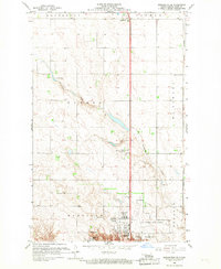
1966 Map of Burlington SE
USGS Topo · Published 1966About this map
Minot and its northern outskirts are captured here during a period of significant mid-century expansion. The northern edge of the city is defined by the burgeoning Minot International Airport and institutional developments like the North Hill Sch. To the north, the small settlement of Ruthville sits at a crossroads, while the rural sections of Eureka and McKinley townships maintain their agricultural character, marked by scattered schools like School No 4 and the North Prairie Ch.
Find a feature on this map
18 named features on this map. Tap any name to fly to it.
Don’t see what you’re looking for? This feature index may not catch every label — zoom into the map to look around manually.
Map Details
Editions of this 1966 Burlington SE Map
2 editions found
Other maps of this area

1928 · Minot
USGS Topo · 1:62,500

1929 · Sawyer
USGS Topo · 1:62,500

1948 · Burlington
USGS Topo · 1:24,000

1948 · Burlington
USGS Topo · 1:62,500

1948 · Minot NW
USGS Topo · 1:24,000

1948 · Surrey
USGS Topo · 1:24,000

1949 · Burlington NW
USGS Topo · 1:24,000

1949 · Minot NW
USGS Topo · 1:24,000

1949 · Deering NW
USGS Topo · 1:24,000

1949 · Deering SW
USGS Topo · 1:24,000