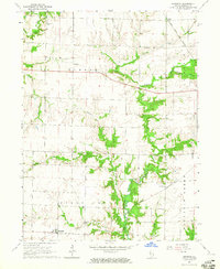
1964 Map of Burnside
USGS Topo · Published 1965About this map
Burnside and La Crosse anchor the southern landscape of this mid-1960s Hancock County survey, where the Toledo Peoria and Western railroad cuts across the agricultural terrain. The map captures a transition in the drainage patterns between Durham in the north and the larger waterways to the south, including the winding La Moine River and its South Branch. Genealogists and local historians will find significant detail in the placement of the Durham Cem, Woodruff Cem, and Pilot Grove Cem, reflecting early settlement patterns in Durham, Pilot Grove, and Fountain Green townships. Small-scale industry is represented by a Quarry situated near the intersection of several local creeks. The drainage network, including Wildcat Creek and Grove Creek, reveals the natural dissection of the Illinois prairie before modern intensive development.
Find a feature on this map
23 named features on this map. Tap any name to fly to it.
Don’t see what you’re looking for? This feature index may not catch every label — zoom into the map to look around manually.
Map Details
Editions of this 1964 Burnside Map
2 editions found
Other maps of this area

1913 · Colchester
USGS Topo · 1:62,500

1918 · La Harpe
USGS Topo · 1:62,500

1932 · Lomax
USGS Topo · 1:62,500

1933 · Carthage
USGS Topo · 1:62,500

1937 · Carthage
USGS Topo · 1:62,500

1937 · Lomax
USGS Topo · 1:62,500

1958 · Burlington
USGS Topo · 1:250,000

1961 · Burlington
USGS Topo · 1:250,000

1963 · Burlington
USGS Topo · 1:250,000

1964 · Lomax
USGS Topo · 1:24,000