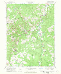
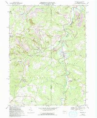
1968 Map of Burnside
USGS Topo · Published 1970About this map
The West Branch Susquehanna River carves through this late 1960s landscape, serving as a corridor for both the Penn Central railroad and a string of industrial and residential clusters. The map reveals an area defined by extensive resource extraction, with numerous strip mines dotting the ridges above the river valley. The industrial character of the era is evidenced by a long conveyor near Lochvale and the presence of Dowler Junction, where rail lines converge to serve the region's coal interests.
Find a feature on this map
51 named features on this map. Tap any name to fly to it.
Don’t see what you’re looking for? This feature index may not catch every label — zoom into the map to look around manually.
Map Details
Editions of this 1968 Burnside Map
5 editions found
Other maps of this area

1902 · Patton
USGS Topo · 1:62,500

1902 · Barnesboro
USGS Topo · 1:62,500

1903 · Curwensville
USGS Topo · 1:62,500

1904 · Barnesboro
USGS Topo · 1:62,500

1904 · Patton
USGS Topo · 1:62,500

1906 · Punxsutawney
USGS Topo · 1:62,500

1939 · Curwensville
USGS Topo · 1:62,500

1939 · Punxsutawney
USGS Topo · 1:62,500

1942 · Curwensville
USGS Topo · 1:62,500

1942 · Punxsutawney
USGS Topo · 1:62,500