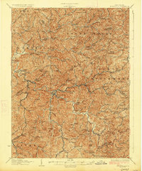
1927 Map of Burnsville
USGS Topo · Published 1927About this map
The Little Kanawha River snakes through the center of this 1920s topography, serving as the primary corridor for the central town of Burnsville. The landscape is a dense network of high ridges and narrow creek bottoms, including Saltlick Creek and Fiddlers Run, which dictated the settlement patterns of central West Virginia. Small rural communities and rural landmarks like Bealls Mills and Stouts Mills are scattered across the terrain, connected by the Baltimore and Ohio railroad line.
Find a feature on this map
135 named features on this map. Tap any name to fly to it.
Don’t see what you’re looking for? This feature index may not catch every label — zoom into the map to look around manually.
Map Details
Editions of this 1927 Burnsville Map
3 editions found

Other maps of this area

1893 · Buckhannon
USGS Topo · 1:125,000

1893 · Sutton
USGS Topo · 1:125,000

1896 · Buckhannon
USGS Topo · 1:125,000

1897 · Buckhannon
USGS Topo · 1:125,000

1904 · Weston
USGS Topo · 1:62,500

1904 · Vadis
USGS Topo · 1:62,500

1906 · Holbrook
USGS Topo · 1:62,500

1906 · Glenville
USGS Topo · 1:62,500

1906 · Burnsville
USGS Topo · 1:62,500

1908 · Gassaway
USGS Topo · 1:48,000