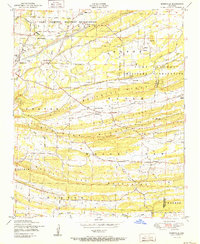
1951 Map of Burnville
USGS Topo · Published 1951About this map
Camp Chaffee Military Reservation dominates the northern half of this landscape, its boundary lines cutting through the terrain just north of the Backbone Ridge system. In this postwar era, the area south of the reservation remains a structured rural community defined by the parallel ridges of the Pinnacle Mountains and the White Oak Mountains. Between these rises lie the productive corridors of Centerville Valley and Washburn Valley. The settlement of Burnville serves as a central hub, featuring the Burnville School and Oak View Farm nearby. To the east, Milltown sits along Washburn Creek, while scattered landmarks like Liberty Church and the Dawson Cemetery anchor the local genealogy of Sebastian County. The military presence is evident through specialized infrastructure, including several Target tracks positioned within the reservation's southern reaches.
Find a feature on this map
38 named features on this map. Tap any name to fly to it.
Don’t see what you’re looking for? This feature index may not catch every label — zoom into the map to look around manually.
Map Details
Editions of this 1951 Burnville Map
2 editions found
Other maps of this area

1879 · Fort Smith
USGS Topo · 1:62,500

1887 · Van Buren
USGS Topo · 1:62,500

1887 · Greenwood
USGS Topo · 1:62,500

1890 · Fort Smith
USGS Topo · 1:125,000

1906 · Lavaca
USGS Topo · 1:62,500

1906 · Barber
USGS Topo · 1:62,500

1943 · Fort Smith
USGS Topo · 1:125,000

1946 · Fort Smith
USGS Topo · 1:250,000
1946 · Charleston
USGS Topo · 1:24,000

1947 · Lavaca
USGS Topo · 1:62,500