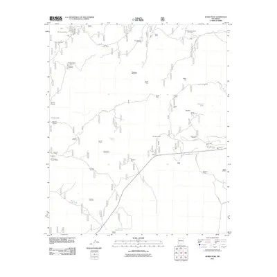
2011 Map of Burro Peak
USGS Topo · Published 2011About this map
Mining operations and ranching life define this high-altitude landscape in the Gila National Forest region. The map reveals an intensive history of mineral extraction, from the Silver Dollar Mine and Austin Amazon Mines in the north to the Red Hill Turquoise Mine and Merry Widow Mine further south. These claims, along with specialized sites like the Gold Gulch Placer and Sunset Gold Field, illustrate the diverse geology that drew prospectors to the area. Settlement is sparse and tied to the land's resources, represented by family holdings such as Silsby Ranch, Russel Ranch, and the Burro Mountain Homestead. This network of human activity is connected by rugged paths like Horseman's Trl and Rustlers Trl, which navigate between prominent heights like Burro Peak and Ferguson Mountain. Water remains a critical and concentrated resource for both livestock and mining, managed through scattered improvements like the Thompson Windmill and Knight Canyon Tank.
Find a feature on this map
57 named features on this map. Tap any name to fly to it.
Don’t see what you’re looking for? This feature index may not catch every label — zoom into the map to look around manually.
Map Details
Editions of this 2011 Burro Peak Map
This is the sole edition of this map. No revisions or reprints were ever made.
Other maps of this area

1909 · Silver City
USGS Topo · 1:125,000

1950 · Tyrone
USGS Topo · 1:24,000

1950 · White Signal
USGS Topo · 1:24,000

1950 · Wind Mountain
USGS Topo · 1:24,000

1950 · Burro Peak
USGS Topo · 1:24,000

1951 · White Signal
USGS Topo · 1:24,000

1951 · Big Burro Mountains
USGS Topo · 1:24,000
1951 · Tyrone
USGS Topo · 1:24,000

1951 · Wind Mountain
USGS Topo · 1:24,000

1954 · Silver City
USGS Topo · 1:250,000