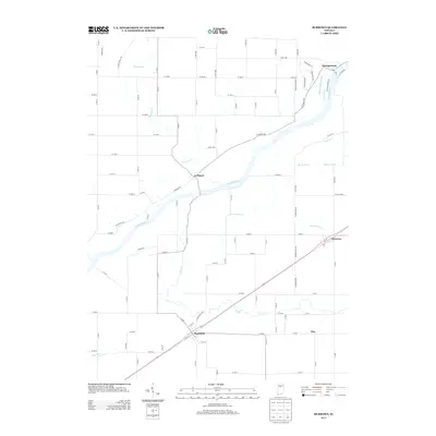
2013 Map of Burrows
USGS Topo · Published 2013About this map
The Wabash River and the historic Wabash and Erie Canal dominate this landscape, tracing a southwest path through Carroll County. The settlement of Lockport sits at a strategic bend in the river, where Towpath Rd follows the old canal route, offering a clear view of the nineteenth-century transportation corridor that once linked the Great Lakes to the Ohio River. To the northeast, Georgetown borders the riverbanks, while the rural communities of Rockfield, Burrows, and Flax anchor the surrounding agricultural lands.
Find a feature on this map
61 named features on this map. Tap any name to fly to it.
Don’t see what you’re looking for? This feature index may not catch every label — zoom into the map to look around manually.
Map Details
Editions of this 2013 Burrows Map
This is the sole edition of this map. No revisions or reprints were ever made.
Other maps of this area

1953 · Danville
USGS Topo · 1:250,000

1955 · Danville
USGS Topo · 1:250,000

1956 · Danville
USGS Topo · 1:250,000

1960 · Lucerne
USGS Topo · 1:24,000

1962 · Deer Creek
USGS Topo · 1:24,000

1962 · Flora
USGS Topo · 1:24,000

1962 · Burrows
USGS Topo · 1:24,000

1962 · Delphi
USGS Topo · 1:24,000

1962 · Burnettsville
USGS Topo · 1:24,000
1962 · Clymers
USGS Topo · 1:24,000