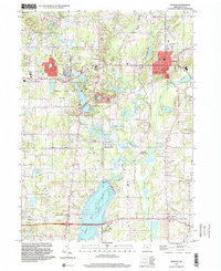
1994 Map of Burton
USGS Topo · Published 2000About this map
Glacial water bodies and conservation lands define the landscape of Geauga County in the mid-1990s. The Cuyahoga River flows through the eastern portion of the map, flanked by the Burton County Wetlands and Russell County Park. The village of Burton sits at a high point above the river valley, serving as a hub for the surrounding townships of Newbury, Auburn, and Troy.
Find a feature on this map
49 named features on this map. Tap any name to fly to it.
Don’t see what you’re looking for? This feature index may not catch every label — zoom into the map to look around manually.
Map Details
Editions of this 1994 Burton Map
This is the sole edition of this map. No revisions or reprints were ever made.
Other maps of this area

1904 · Chardon
USGS Topo · 1:62,500

1905 · Garrettsville
USGS Topo · 1:62,500

1905 · Mentor
USGS Topo · 1:62,500

1906 · Chardon
USGS Topo · 1:62,500

1906 · Chagrin Falls
USGS Topo · 1:62,500

1907 · Garrettsville
USGS Topo · 1:62,500

1907 · Mentor
USGS Topo · 1:62,500

1908 · Chagrin Falls
USGS Topo · 1:62,500

1950 · Cleveland
USGS Topo · 1:250,000

1953 · Chardon
USGS Topo · 1:24,000
Featured Places
- Burton Township, OH
- Burton Village, OH
- Welshfield, Troy Township
- Auburn Township, OH
- Munson Township, OH