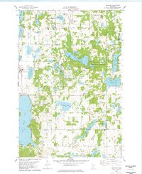
1978 Map of Burtrum
USGS Topo · Published 1978About this map
The borderlands of Todd, Stearns, and Morrison counties are defined by a complex glacial landscape of interconnected wetlands and lakes. In the late 1970s, the village of Grey Eagle served as a primary hub west of Big Birch Lake, while the smaller settlement of Burtrum anchored the northern section of the map near Big Swan Lake. The area is notably dense with conservation lands, including the Oak Ridge State Wildlife Management Area and the National Waterfowl Production Area, reflecting the region's importance for migratory birds and local ecology. For genealogists, the map identifies several distinct burial grounds such as the G A R Cem and Old St Marys Cem, alongside established lakeside communities like North Shore and Pleasant Beach. The terrain is punctuated by landmarks such as Eagle Mountain and Hill Lake, illustrating the varied elevations between the countless water bodies like Mound Lake and Cedar Lake.
Find a feature on this map
53 named features on this map. Tap any name to fly to it.
Don’t see what you’re looking for? This feature index may not catch every label — zoom into the map to look around manually.
Map Details
Editions of this 1978 Burtrum Map
This is the sole edition of this map. No revisions or reprints were ever made.
Other maps of this area

1947 · Flensburg
USGS Topo · 1:25,000

1950 · Swanville
USGS Topo · 1:62,500

1951 · Flensburg
USGS Topo · 1:25,000

1953 · Saint Cloud
USGS Topo · 1:250,000

1957 · Saint Cloud
USGS Topo · 1:250,000

1958 · Saint Cloud
USGS Topo · 1:250,000

1965 · Albany
USGS Topo · 1:24,000

1965 · Melrose
USGS Topo · 1:24,000

1965 · Freeport
USGS Topo · 1:24,000
1966 · Long Prairie
USGS Topo · 1:24,000