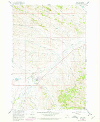
1958 Map of Busby
USGS Topo · Published 1978About this map
Busby serves as the focal point of this 1950s survey within the Northern Cheyenne Indian Reservation, where the community is anchored by the Busby Boarding Sch and the Busby Cem. A notable Historical Monument commemorating Indian Chief Two Moons stands nearby, marking the intersection of local heritage and the landscape. The terrain is defined by a dense network of drainages, including Rosebud Creek, Porcupine Creek, and Teeth Creek, which carve through the high ground of Red Hill and Busby Butte. Evidence of early resource extraction and water management is visible through the Busby Mine, several Gravel Pits, and the Government Ditch. The geography is characterized by numerous seasonal and perennial forks, such as Little Hawk Creek and Deafy Creek, illustrating the complex watershed of Big Horn County during this era.
Find a feature on this map
30 named features on this map. Tap any name to fly to it.
Don’t see what you’re looking for? This feature index may not catch every label — zoom into the map to look around manually.
Map Details
Editions of this 1958 Busby Map
3 editions found
Other maps of this area

1894 · Rosebud
USGS Topo · 1:125,000

1901 · Rosebud
USGS Topo · 1:125,000

1954 · Hardin
USGS Topo · 1:250,000

1957 · Hardin
USGS Topo · 1:250,000

1958 · Hardin
USGS Topo · 1:250,000

1958 · Chalky Point
USGS Topo · 1:24,000

1958 · Painted Hill
USGS Topo · 1:24,000

1958 · Bull Creek Lookout
USGS Topo · 1:24,000

1958 · Black Spring
USGS Topo · 1:24,000

1958 · Busby
USGS Topo · 1:24,000