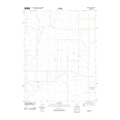
2010 Map of Bushong
USGS Topo · Published 2010About this map
Bushong sits at the southeastern corner of this rural Kansas landscape, where a grid of section roads and small watercourses defines the agricultural character of Lyon County. The town site is detailed with its local street plan, including 1st St, E 2nd St, and W 4th St, reflecting a small-town layout that has endured through the early 21st century. The surrounding countryside is drained by the winding paths of Rock Creek, Bluff Creek, and Horse Creek, which cut across the geometric regularity of the land parcels. Evidence of the area's earlier pioneer history remains visible through the Agnes City Cemetery and Comisky Cemetery, providing specific points of interest for genealogists tracing family roots in this part of the Flint Hills region. The presence of these burial grounds alongside modern designations like Highway 56 illustrates the layer of heritage underlying the modern topographic record.
Find a feature on this map
26 named features on this map. Tap any name to fly to it.
Don’t see what you’re looking for? This feature index may not catch every label — zoom into the map to look around manually.
Map Details
Editions of this 2010 Bushong Map
This is the sole edition of this map. No revisions or reprints were ever made.
Other maps of this area

1885 · Eskridge
USGS Topo · 1:125,000

1889 · Eskridge
USGS Topo · 1:125,000

1894 · Eskridge
USGS Topo · 1:125,000

1955 · Hutchinson
USGS Topo · 1:250,000

1959 · Hutchinson
USGS Topo · 1:250,000

1971 · Alta Vista SE
USGS Topo · 1:24,000

1971 · Allen
USGS Topo · 1:24,000

1971 · Bushong
USGS Topo · 1:24,000

1971 · Alta Vista
USGS Topo · 1:24,000
1971 · Lake Wabaunsee
USGS Topo · 1:24,000