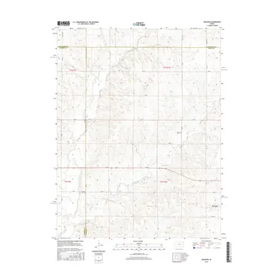
2015 Map of Bushong
USGS Topo · Published 2015About this map
The intersection of Morris and Lyon counties defines this rural landscape, where the small settlement of Bushong sits at the eastern edge of the quadrangle. This 2015 U.S. Geological Survey data illustrates a transition from the rolling drainage basins of Rock Creek and Bluff Creek to the established grid of section roads like Agnes City Rd and Barbwire Rd. Local history is anchored by sites such as the Agnes City Cem and the small locality of Comisky, providing essential geographic context for the region's homesteading and ranching heritage. The terrain is marked by numerous seasonal tributaries, including Wrights Cr and Horse Cr, which carve through the Flint Hills region and dictate the placement of early rural infrastructure.
Find a feature on this map
36 named features on this map. Tap any name to fly to it.
Don’t see what you’re looking for? This feature index may not catch every label — zoom into the map to look around manually.
Map Details
Editions of this 2015 Bushong Map
This is the sole edition of this map. No revisions or reprints were ever made.
Other maps of this area

1885 · Eskridge
USGS Topo · 1:125,000

1889 · Eskridge
USGS Topo · 1:125,000

1894 · Eskridge
USGS Topo · 1:125,000

1955 · Hutchinson
USGS Topo · 1:250,000

1959 · Hutchinson
USGS Topo · 1:250,000

1971 · Alta Vista SE
USGS Topo · 1:24,000

1971 · Allen
USGS Topo · 1:24,000

1971 · Bushong
USGS Topo · 1:24,000

1971 · Alta Vista
USGS Topo · 1:24,000
1971 · Lake Wabaunsee
USGS Topo · 1:24,000