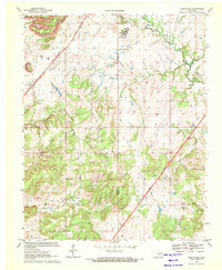
1970 Map of Bushyhead
USGS Topo · Published 1971About this map
Bushyhead sits along the St Louis - San Francisco rail line in Rogers County, Oklahoma, at a time when the region's landscape was actively shaped by surface mining. Extensive strip mines and gravel pits mark the northern and southern quadrants, while the central terrain is dominated by the Foyil and Ridger topographic features. This era shows the modern infrastructure of the Will Rogers Toll Road Turnpike cutting through the countryside, contrasting with the older rural network of churches and family burial grounds. Local history is deeply rooted in these small communities, visible through sites like Lone Chapel, Good Hope Ch, and the Washington Cem. The drainage patterns of Pryor Creek and Dog Creek dictate the layout of the remaining agricultural land, showing how water and industry dictated the placement of early settlements like Howard and Hulda.
Find a feature on this map
36 named features on this map. Tap any name to fly to it.
Don’t see what you’re looking for? This feature index may not catch every label — zoom into the map to look around manually.
Map Details
Editions of this 1970 Bushyhead Map
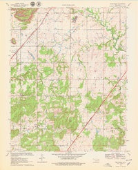
2 editions found
Other maps of this area

1896 · Pryor
USGS Topo · 1:125,000

1901 · Claremore
USGS Topo · 1:125,000

1901 · Nowata
USGS Topo · 1:125,000

1901 · Vinita
USGS Topo · 1:125,000

1901 · Pryor
USGS Topo · 1:125,000

1913 · Vinita
USGS Topo · 1:125,000

1914 · Nowata
USGS Topo · 1:125,000

1914 · Claremore
USGS Topo · 1:125,000

1916 · Claremore
USGS Topo · 1:125,000

1954 · Tulsa
USGS Topo · 1:250,000