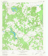
1964 Map of Butler
USGS Topo · Published 1981About this map
The Trinity River forms a defining boundary for this Freestone County landscape, where small rural communities and family-centered institutions anchored mid-century life. The map centers on Butler, a hub characterized by the Butler High Sch and nearby Roadside Park. To the east, the Daniel Memorial WT Childrens Home stands as a significant landmark near the Saline Branch. This era shows a topography defined by complex water management, with Red Lake, Burleson Lake, and Little Red Lake featuring prominent spillways.
Find a feature on this map
34 named features on this map. Tap any name to fly to it.
Don’t see what you’re looking for? This feature index may not catch every label — zoom into the map to look around manually.
Map Details
Editions of this 1964 Butler Map
3 editions found
Other maps of this area

1919 · Fairfield
USGS Topo · 1:62,500

1949 · Tennessee Colony
USGS Topo · 1:62,500

1950 · Tennessee Colony
USGS Topo · 1:62,500

1953 · Palestine
USGS Topo · 1:250,000

1954 · Waco
USGS Topo · 1:250,000

1955 · Waco
USGS Topo · 1:250,000

1957 · Palestine
USGS Topo · 1:250,000

1961 · Young
USGS Topo · 1:24,000

1964 · Long Lake
USGS Topo · 1:24,000

1964 · Oakwood
USGS Topo · 1:24,000