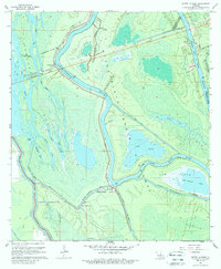
1968 Map of Butte La Rose
USGS Topo · Published 1988About this map
The Atchafalaya Basin Floodway dominates this mid-century landscape, revealing a complex network of waterways and managed drainage in St. Martin Parish. The settlement of Butte La Rose sits at a critical bend where Bayou La Rose meets the Atchafalaya River, serving as a hub for local river navigation. To the west, the map details the intricate hydraulics of Opelousas Bay and Haha Bay, while the Whisky Bay Pilot Channel and the Butte La Rose Cutoff demonstrate the extensive engineering efforts used to control the basin's flow. Industry is visible at the Bouillon Gas and Oil Field, reflecting the area's economic reliance on natural resources. Local landmarks like the Atchafalaya Radio Tower at Pelba and the Davis Roadside Park provide specific points of reference for those researching the historical geography of this wetland region.
Find a feature on this map
35 named features on this map. Tap any name to fly to it.
Don’t see what you’re looking for? This feature index may not catch every label — zoom into the map to look around manually.
Map Details
Editions of this 1968 Butte La Rose Map
4 editions found
Other maps of this area

1935 · Osca Bayou
USGS Topo · 1:62,500

1939 · St. Martinsville
USGS Topo · 1:62,500

1940 · Arnaudville
USGS Topo · 1:62,500

1941 · Loreauville
USGS Topo · 1:62,500

1953 · Cow Bayou
USGS Topo · 1:24,000

1953 · Maringouin
USGS Topo · 1:24,000

1954 · Loreauville
USGS Topo · 1:62,500

1954 · Baton Rouge
USGS Topo · 1:250,000

1955 · Osca Bayou
USGS Topo · 1:62,500

1956 · Baton Rouge
USGS Topo · 1:250,000