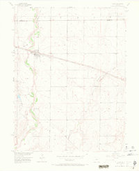
1956 Map of Byers
USGS Topo · Published 1972About this map
The town of Byers sits at the heart of this high plains landscape, situated along the critical transit corridor of the Union Pacific railroad. The community's local infrastructure is clearly documented in the mid-1950s, showing a concentrated grid of streets, a designated Cem, and a municipal Waterworks. The physical geography is defined by the braided channels and broad floodplains of West Bijou Creek, which winds through the western portion of the survey. East of the main settlement, the rural character of the region is emphasized by isolated landmarks like the Bellview Sch and the winding course of Rattlesnake Creek. This survey captures the intersection of early Colorado rail infrastructure and the intermittent water sources that dictated settlement patterns in the eastern plains.
Find a feature on this map
8 named features on this map. Tap any name to fly to it.
Don’t see what you’re looking for? This feature index may not catch every label — zoom into the map to look around manually.
Map Details
Editions of this 1956 Byers Map
5 editions found
Other maps of this area

1950 · Roper School
USGS Topo · 1:24,000

1951 · Roper School
USGS Topo · 1:24,000

1951 · Leader SE
USGS Topo · 1:24,000

1952 · Leader SW
USGS Topo · 1:24,000

1953 · Denver
USGS Topo · 1:250,000

1955 · Strasburg
USGS Topo · 1:24,000

1956 · Peoria
USGS Topo · 1:24,000

1956 · Byers
USGS Topo · 1:24,000

1957 · Denver
USGS Topo · 1:250,000

1958 · Denver
USGS Topo · 1:250,000