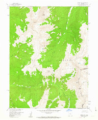
1957 Map of Byers Peak
USGS Topo · Published 1963About this map
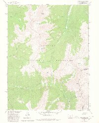
The Continental Divide snake-like through the high alpine country of the Arapaho National Forest, marking the boundary between Grand Co and Clear Creek Co. This 1957 field-checked survey reveals an era of significant mountain engineering, highlighted by the Jones Pass Tunnel and the St Louis Aqueduct cutting through the peaks. Resource extraction is evident at the Bootail Mine and an unnamed mine near St Louis Lake. The landscape is dominated by high-altitude summits including Byers Peak, Mt Nystrom, and St Louis Peak. Water management and natural hydrology define the terrain, from the headwaters of the South Fork Williams Fork to high-elevation basins like Horseshoe Lake and McQueary Lake. The Byers Peak Trail provides a trace of mid-century recreational access through the steep drainages of Keyser Creek and St Louis Creek.
Find a feature on this map
35 named features on this map. Tap any name to fly to it.
Don’t see what you’re looking for? This feature index may not catch every label — zoom into the map to look around manually.
Map Details
Editions of this 1957 Byers Peak Map
7 editions found
Other maps of this area

1924 · Montezuma
USGS Topo · 1:62,500

1924 · Fraser
USGS Topo · 1:62,500

1926 · Fraser
USGS Topo · 1:62,500

1926 · Montezuma
USGS Topo · 1:62,500

1929 · Dillon
USGS Topo · 1:62,500

1933 · Montezuma
USGS Topo · 1:62,500

1933 · Ute Peak
USGS Topo · 1:62,500

1934 · Dillon
USGS Topo · 1:62,500

1937 · Ute Peak
USGS Topo · 1:62,500

1953 · Denver
USGS Topo · 1:250,000