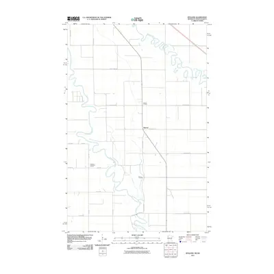
2011 Map of Bygland
USGS Topo · Published 2011About this map
Bygland anchors this Polk County landscape, situated where the meandering Red Lake River flows toward its confluence with the Red River of the North. This 2011 survey illustrates a region defined by its watercourses and a rigid grid of agricultural roads, such as County Hwy-58 and County Hwy-223. Local heritage is centered around the East Welle Evangelical Lutheran church and the nearby Bygland Cemetery, which serve as long-standing community landmarks. Farther south along the riverbanks, the Pioneer Cemetery indicates the early roots of European settlement in this fertile valley. The map details the intricate loops and oxbows of the river systems, reflecting a terrain where the natural hydrology and a legacy of rural farming have dictated the development of the township and its surrounding section lines.
Find a feature on this map
23 named features on this map. Tap any name to fly to it.
Don’t see what you’re looking for? This feature index may not catch every label — zoom into the map to look around manually.
Map Details
Editions of this 2011 Bygland Map
This is the sole edition of this map. No revisions or reprints were ever made.
Other maps of this area

1919 · Eldred
USGS Topo · 1:62,500

1934 · Grand Forks
USGS Topo · 1:24,000

1934 · Grand Forks
USGS Topo · 1:62,500

1938 · Grand Forks
USGS Topo · 1:62,500

1952 · Grand Forks
USGS Topo · 1:250,000

1956 · Grand Forks
USGS Topo · 1:250,000
1963 · Mallory
USGS Topo · 1:24,000
1963 · Key West
USGS Topo · 1:24,000
1963 · Grand Forks
USGS Topo · 1:24,000

1964 · Climax NW
USGS Topo · 1:24,000