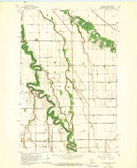
1964 Map of Bygland
USGS Topo · Published 1966About this map
The Red River meanders along the border of Minnesota and North Dakota in this mid-1960s study of the Red River Valley. The landscape is defined by the sharp contrast between the winding, wooded corridors of the Red Lake River and the rigid, engineered grid of the surrounding agricultural townships. Rural life is anchored by small community centers like the settlement of Bygland, where the Bygland Ch and nearby Oak Valle Ch served the local farming families.
Find a feature on this map
27 named features on this map. Tap any name to fly to it.
Don’t see what you’re looking for? This feature index may not catch every label — zoom into the map to look around manually.
Map Details
Editions of this 1964 Bygland Map
This is the sole edition of this map. No revisions or reprints were ever made.
Other maps of this area

1919 · Eldred
USGS Topo · 1:62,500

1934 · Grand Forks
USGS Topo · 1:24,000

1934 · Grand Forks
USGS Topo · 1:62,500

1938 · Grand Forks
USGS Topo · 1:62,500

1952 · Grand Forks
USGS Topo · 1:250,000

1956 · Grand Forks
USGS Topo · 1:250,000
1963 · Mallory
USGS Topo · 1:24,000
1963 · Key West
USGS Topo · 1:24,000
1963 · Grand Forks
USGS Topo · 1:24,000

1964 · Climax NW
USGS Topo · 1:24,000