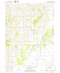
1953 Map of Bynumville
USGS Topo · Published 1979About this map
Bynumville and Hamden serve as the primary hubs in this agricultural landscape of northern Chariton County during the mid-20th century. The terrain is defined by the significant hydraulic engineering of the Chariton River, where an Old Channel remains visible alongside extensive modern levee systems and a spoil bank. This intersection of natural waterways and human-made flood control measures illustrates the region's efforts to manage the river's fertile but volatile bottomlands.
Find a feature on this map
27 named features on this map. Tap any name to fly to it.
Don’t see what you’re looking for? This feature index may not catch every label — zoom into the map to look around manually.
Map Details
Editions of this 1953 Bynumville Map
2 editions found
Other maps of this area

1890 · Glasgow
USGS Topo · 1:125,000

1953 · Moberly
USGS Topo · 1:250,000

1953 · Marceline
USGS Topo · 1:24,000

1953 · Clifton Hill
USGS Topo · 1:24,000

1953 · Prairie Hill
USGS Topo · 1:24,000

1953 · Lagonda
USGS Topo · 1:24,000

1953 · Wien
USGS Topo · 1:24,000

1953 · Bynumville
USGS Topo · 1:24,000
1953 · Mike
USGS Topo · 1:24,000

1954 · Moberly
USGS Topo · 1:250,000