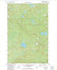
1982 Map of Cabin Lake
USGS Topo · Published 1982About this map
The Cramer Homestead sits near the southern edge of this North Shore landscape, where the Manitou River cuts through the heavy timber of the Superior National Forest and Finland State Forest. The map documents a territory defined by its complex hydrography, including Moose Lake, Balsam Lake, and the smaller Cabin Lake. This 1982 edition illustrates the footprint of early industrial and transportation routes through the wilderness, specifically noting the Old Railroad Grade and the General Grade Road which likely serviced the region's timber or mining interests. To the southeast, the George H Crosby Manitou State Park encompasses the lower reaches of the Manitou River, where the terrain becomes increasingly fractured by Rock Cut Creek and various rapids. Several Gravel Pit sites are scattered along the northwestern corridors, marking the points of material extraction for local infrastructure projects within Crystal Bay.
Find a feature on this map
30 named features on this map. Tap any name to fly to it.
Don’t see what you’re looking for? This feature index may not catch every label — zoom into the map to look around manually.
Map Details
Editions of this 1982 Cabin Lake Map
2 editions found
Other maps of this area

1954 · Silver Bay
USGS Topo · 1:62,500

1954 · Two Harbors
USGS Topo · 1:250,000

1955 · Isabella
USGS Topo · 1:62,500

1955 · Cramer
USGS Topo · 1:62,500

1956 · Little Marais
USGS Topo · 1:24,000

1956 · Finland
USGS Topo · 1:24,000

1956 · Finland
USGS Topo · 1:62,500

1957 · Two Harbors
USGS Topo · 1:250,000

1958 · Two Harbors
USGS Topo · 1:250,000

1964 · Two Harbors
USGS Topo · 1:250,000