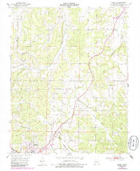
1951 Map of Cabool NE
USGS Topo · Published 1985About this map
The Big Piney River winds through this Ozark landscape, anchoring a rural network of small communities and family-named landmarks during the mid-20th century. The settlement of Simmons and the outskirts of Cabool serve as primary hubs, connected by the tracks of the Burlington Northern railroad. The map reveals a high density of rural institutions that once served these dispersed neighborhoods, including several small country schools such as Shady Grove School and Simmons School.
Find a feature on this map
30 named features on this map. Tap any name to fly to it.
Don’t see what you’re looking for? This feature index may not catch every label — zoom into the map to look around manually.
Map Details
Editions of this 1951 Cabool NE Map
4 editions found
Other maps of this area

1941 · Bado
USGS Topo · 1:62,500

1943 · Bado
USGS Topo · 1:62,500

1945 · Clear Springs
USGS Topo · 1:62,500

1948 · Clear Springs
USGS Topo · 1:62,500

1949 · Rolla
USGS Topo · 1:250,000

1950 · Cabool SW
USGS Topo · 1:24,000

1951 · Cabool SE
USGS Topo · 1:24,000

1951 · Houston
USGS Topo · 1:24,000

1951 · Cabool NW
USGS Topo · 1:24,000

1951 · Cabool NE
USGS Topo · 1:24,000