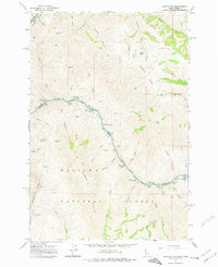
1963 Map of Cactus Mtn
USGS Topo · Published 1976About this map
Snake River and Salmon River dominate this landscape along the Idaho-Oregon border, where deep canyons carve through the Wallowa-Whitman National Forest. The map documents a period when the river was primarily navigated by its series of formidable rapids, including Zigzag Rapids, Whitehorse Rapids, and Dug Bar Rapids. Remote human activity is centered around the Spencer Ranch and its adjacent Landing Strip, illustrating the reliance on air and water access in this steep terrain. Prominent landmarks such as Sugarloaf Butte and the Wallowa Summit Ridge provide distinct navigational points above the canyons. Genealogists and historians can locate specific points of local movement like the Cow Creek Bridge and trace the complex series of gulches and creeks that defined early boundaries in this tri-county intersection.
Find a feature on this map
60 named features on this map. Tap any name to fly to it.
Don’t see what you’re looking for? This feature index may not catch every label — zoom into the map to look around manually.
Map Details
Editions of this 1963 Cactus Mtn Map
2 editions found
Other maps of this area

1954 · Imnaha
USGS Topo · 1:62,500

1954 · Kernan Point
USGS Topo · 1:62,500

1955 · Grangeville
USGS Topo · 1:250,000

1959 · Grangeville
USGS Topo · 1:250,000

1963 · Cactus Mtn
USGS Topo · 1:24,000

1963 · Deadhorse Ridge
USGS Topo · 1:24,000

1963 · Boles
USGS Topo · 1:24,000

1963 · Rattlesnake Ridge
USGS Topo · 1:24,000

1963 · Wapshilla Creek
USGS Topo · 1:24,000

1963 · Wolf Creek
USGS Topo · 1:24,000