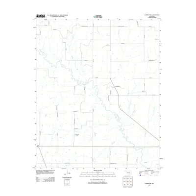
2012 Map of Caddo NW
USGS Topo · Published 2012About this map
Blue River carves a winding path through this corner of south-central Oklahoma, dictating the geography of the surrounding rural landscape. The settlement of Folsom sits at a crossroads in the eastern half of the map, while the small community of Nida is located near the southwestern boundary. This region is characterized by an extensive network of creeks and tributaries, including Sandy Cr, Reeder Cr, and Horse Cr, which feed into the larger river system. The presence of Twelvemile Prairie suggests the open, grassland character of the terrain between these wooded waterways. Genealogists and local historians can locate several family and community landmarks, such as Center Hill Cem and Nail Cem, providing points of reference for families tied to Johnston County and the surrounding plains.
Find a feature on this map
49 named features on this map. Tap any name to fly to it.
Don’t see what you’re looking for? This feature index may not catch every label — zoom into the map to look around manually.
Map Details
Editions of this 2012 Caddo NW Map
This is the sole edition of this map. No revisions or reprints were ever made.
Other maps of this area

1899 · Atoka
USGS Topo · 1:125,000

1900 · Atoka
USGS Topo · 1:125,000

1901 · Tishomingo
USGS Topo · 1:125,000

1957 · Ardmore
USGS Topo · 1:250,000

1963 · Ardmore
USGS Topo · 1:250,000

1967 · Connerville SE
USGS Topo · 1:24,000
1967 · Little City
USGS Topo · 1:24,000
1967 · Milburn
USGS Topo · 1:24,000
1968 · Wapanucka South
USGS Topo · 1:24,000

1968 · Caddo NW
USGS Topo · 1:24,000