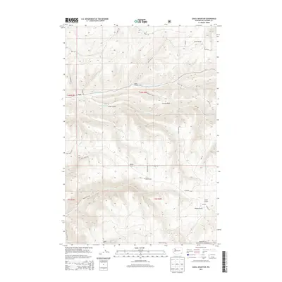
2013 Map of Cahill Mountain
USGS Topo · Published 2013About this map
Patit sits at the junction of several drainage systems in the Blue Mountains foothills, where Patit Cr meets its northern and western branches. This landscape is defined by its deep incisions and high ridges, notably Starvout Ridge and Cahill Mtn, which overlook a network of hollows and gulches used for local transit. The density of named rural roads, such as Malcolm Grade Rd and Hatley Gulch Rd, suggests a territory deeply partitioned for agricultural or timber use. To the south, the topography transitions into the Umatilla National Forest, home to Pioneer Memorial Park. This 2013 survey provides a clear look at the persistent naming conventions of the region, from Lewis Hollow to Cougar Canyon, reflecting the family names and wildlife that shaped the identity of this Washington landscape.
Find a feature on this map
35 named features on this map. Tap any name to fly to it.
Don’t see what you’re looking for? This feature index may not catch every label — zoom into the map to look around manually.
Map Details
Editions of this 2013 Cahill Mountain Map
This is the sole edition of this map. No revisions or reprints were ever made.
Other maps of this area

1937 · Pomeroy
USGS Topo · 1:96,000

1942 · Pomeroy
USGS Topo · 1:125,000

1955 · Pullman
USGS Topo · 1:250,000

1958 · Pullman
USGS Topo · 1:250,000
1967 · Robinette Mtn.
USGS Topo · 1:24,000

1967 · Hopkins Ridge
USGS Topo · 1:24,000

1967 · Cahill Mtn
USGS Topo · 1:24,000

1967 · Turner
USGS Topo · 1:24,000
1967 · Dayton
USGS Topo · 1:24,000
1967 · Panjab Creek
USGS Topo · 1:24,000