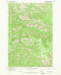
1967 Map of Panjab Creek
USGS Topo · Published 1971About this map
Camp Wooten State Park and the deep drainage of the Tucannon River anchor this topographic survey of the Blue Mountains region. The landscape is defined by its high ridges and a dense network of water sources, including Cascara Spring, Alnus Spring, and Table Spring. These reliable water points and the sheltered valleys formed by Panjab Creek and Turkey Creek have long supported seasonal activity within the Umatilla National Forest.
Find a feature on this map
40 named features on this map. Tap any name to fly to it.
Don’t see what you’re looking for? This feature index may not catch every label — zoom into the map to look around manually.
Map Details
Editions of this 1967 Panjab Creek Map
3 editions found
Other maps of this area

1937 · Pomeroy
USGS Topo · 1:96,000

1942 · Pomeroy
USGS Topo · 1:125,000

1955 · Pullman
USGS Topo · 1:250,000

1958 · Pullman
USGS Topo · 1:250,000

1967 · Rose Springs
USGS Topo · 1:24,000

1967 · Hopkins Ridge
USGS Topo · 1:24,000

1967 · Cahill Mtn
USGS Topo · 1:24,000

1967 · Oregon Butte
USGS Topo · 1:24,000

1967 · Stentz Spring
USGS Topo · 1:24,000
1967 · Diamond Peak
USGS Topo · 1:24,000