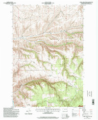
1995 Map of Cahill Mountain
USGS Topo · Published 1998About this map
Cahill Mountain dominates this high-country terrain within the Umatilla National Forest, where deep drainages like Cougar Canyon and Lewis Hollow carve through the landscape. The map captures a moment when land use was defined by forest service infrastructure and old mountain passages, most notably the Patit (Site) located along North Patit Creek. The presence of the Thorn Lookout and the Pioneer Memorial Park suggests a region valued for its vantage points and conservation history during the mid-1990s.
Find a feature on this map
21 named features on this map. Tap any name to fly to it.
Don’t see what you’re looking for? This feature index may not catch every label — zoom into the map to look around manually.
Map Details
Editions of this 1995 Cahill Mountain Map
This is the sole edition of this map. No revisions or reprints were ever made.
Other maps of this area

1937 · Pomeroy
USGS Topo · 1:96,000

1942 · Pomeroy
USGS Topo · 1:125,000

1955 · Pullman
USGS Topo · 1:250,000

1958 · Pullman
USGS Topo · 1:250,000
1967 · Robinette Mtn.
USGS Topo · 1:24,000

1967 · Hopkins Ridge
USGS Topo · 1:24,000

1967 · Cahill Mtn
USGS Topo · 1:24,000

1967 · Turner
USGS Topo · 1:24,000
1967 · Dayton
USGS Topo · 1:24,000
1967 · Panjab Creek
USGS Topo · 1:24,000