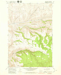
1976 Map of Cahill Mtn
USGS Topo · Published 1980About this map
Cahill Mountain and the surrounding drainages of Patit Creek define this landscape in southeastern Washington during the mid-1970s. The map centers on a series of deeply etched gulches and canyons, including Rodgers Gulch and Cougar Canyon, which fall away from high points like Starvout Ridge. A ghost of former settlement is found at Patit (Site), located where the north and west forks of the creek meet. The area is heavily managed for forest and recreation, indicated by the presence of the Umatilla N F and the Pioneer Memorial Park. Ridge-top travel is facilitated by the Kendall Skyline Road and the Malcolm Grade Road, which provide access to the Thorn Lookout Tower overlooking Kendall Gulch. This survey captures the transition between agricultural valley floors and the high timber of the Blue Mountains, recording early timber roads and jeep trails that carved through the remote drainages.
Find a feature on this map
24 named features on this map. Tap any name to fly to it.
Don’t see what you’re looking for? This feature index may not catch every label — zoom into the map to look around manually.
Map Details
Editions of this 1976 Cahill Mtn Map
This is the sole edition of this map. No revisions or reprints were ever made.
Other maps of this area

1937 · Pomeroy
USGS Topo · 1:96,000

1942 · Pomeroy
USGS Topo · 1:125,000

1955 · Pullman
USGS Topo · 1:250,000

1958 · Pullman
USGS Topo · 1:250,000
1967 · Robinette Mtn.
USGS Topo · 1:24,000

1967 · Hopkins Ridge
USGS Topo · 1:24,000

1967 · Cahill Mtn
USGS Topo · 1:24,000

1967 · Turner
USGS Topo · 1:24,000
1967 · Dayton
USGS Topo · 1:24,000
1967 · Panjab Creek
USGS Topo · 1:24,000