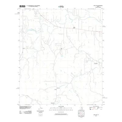
2010 Map of Cain City
USGS Topo · Published 2010About this map
Cain City and the famous crossroads of Luckenbach define this central Texas landscape south of Fredericksburg. The terrain is characterized by the watershed of the Pedernales River and its numerous tributaries, including South Grape Creek and Muesebach Creek. Settlement patterns are evident in the small communities of Grapetown and Bankersmith, which are connected by historic thoroughfares like Old Fred Rd and Grape Creek Rd. For those researching regional genealogy, the presence of the Meusebach Cemetery and Grapetown Cemetery offers specific points for tracing local family lineages. The map also captures the varied topography of the area, from the prominence of Rocky Hill to the winding courses of Snake Creek and Salt Creek, illustrating the rural character of Gillespie County as it remained into the early 21st century.
Find a feature on this map
19 named features on this map. Tap any name to fly to it.
Don’t see what you’re looking for? This feature index may not catch every label — zoom into the map to look around manually.
Map Details
Editions of this 2010 Cain City Map
This is the sole edition of this map. No revisions or reprints were ever made.
Other maps of this area

1894 · Fredericksburg
USGS Topo · 1:125,000

1954 · Llano
USGS Topo · 1:250,000

1955 · Llano
USGS Topo · 1:250,000

1956 · Llano
USGS Topo · 1:250,000

1961 · Stonewall
USGS Topo · 1:24,000

1961 · Cave Creek School
USGS Topo · 1:24,000

1963 · Whitworth Ranch
USGS Topo · 1:24,000

1963 · Cain City
USGS Topo · 1:24,000

1964 · Oak Crest Park
USGS Topo · 1:24,000
1964 · Rafter Hollow
USGS Topo · 1:24,000