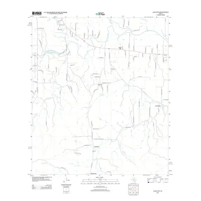
2012 Map of Cain City
USGS Topo · Published 2012About this map
Cain City and the surrounding Gillespie County ranch lands appear here in the early 21st century, centered on the network of creeks feeding the Pedernales River. This landscape is defined by its small, traditional settlements and family-named landmarks, reflecting a deep-rooted agricultural heritage. To the east, the community of Luckenbach sits near the banks of S Grape Cr, while Grapetown and its associated Grapetown Cem occupy the southern portion of the sheet. The terrain transitions toward the south near Bankersmith, where drainage from Hopf's Cr and School Cr carves through the local topography. Notable historical sites, including the Meusebach Cem and the prominent Rocky Hill, provide anchors for genealogical research and a sense of the area's original pioneer footprint. The drainage patterns of Snake Cr and Muesebach Cr illustrate the complex watershed that has shaped local property lines and road placements for generations.
Find a feature on this map
90 named features on this map. Tap any name to fly to it.
Don’t see what you’re looking for? This feature index may not catch every label — zoom into the map to look around manually.
Map Details
Editions of this 2012 Cain City Map
This is the sole edition of this map. No revisions or reprints were ever made.
Other maps of this area

1894 · Fredericksburg
USGS Topo · 1:125,000

1954 · Llano
USGS Topo · 1:250,000

1955 · Llano
USGS Topo · 1:250,000

1956 · Llano
USGS Topo · 1:250,000

1961 · Stonewall
USGS Topo · 1:24,000

1961 · Cave Creek School
USGS Topo · 1:24,000

1963 · Whitworth Ranch
USGS Topo · 1:24,000

1963 · Cain City
USGS Topo · 1:24,000

1964 · Oak Crest Park
USGS Topo · 1:24,000
1964 · Rafter Hollow
USGS Topo · 1:24,000