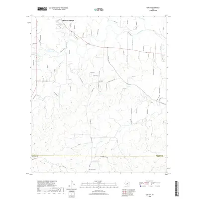
2019 Map of Cain City
USGS Topo · Published 2019About this map
Cain City and the southern outskirts of Fredericksburg anchor this 2019 survey of the Texas Hill Country, where the landscape is defined by the drainage network of the Pedernales River. The map captures the rural character of the region as it transitions from the limestone ridges and creek bottoms into the northern reaches of Kendall County. Evidence of the area's early German heritage is preserved in the location of the Meusebach Cem and Grapetown Cem, while family-named landmarks like Wild Flowers Hill and Rocky Hill Ln suggest long-standing local ties to the land. The drainage patterns of Palo Alto Creek, Snake Cr, and S Grape Cr illustrate the complex topography that historically influenced the placement of early settlements and roads like Ranch Rd 1376, which winds through the valley south of Fredericksburg.
Find a feature on this map
88 named features on this map. Tap any name to fly to it.
Don’t see what you’re looking for? This feature index may not catch every label — zoom into the map to look around manually.
Map Details
Editions of this 2019 Cain City Map
This is the sole edition of this map. No revisions or reprints were ever made.
Other maps of this area

1894 · Fredericksburg
USGS Topo · 1:125,000

1954 · Llano
USGS Topo · 1:250,000

1955 · Llano
USGS Topo · 1:250,000

1956 · Llano
USGS Topo · 1:250,000

1961 · Stonewall
USGS Topo · 1:24,000

1961 · Cave Creek School
USGS Topo · 1:24,000

1963 · Whitworth Ranch
USGS Topo · 1:24,000

1963 · Cain City
USGS Topo · 1:24,000

1964 · Oak Crest Park
USGS Topo · 1:24,000
1964 · Rafter Hollow
USGS Topo · 1:24,000