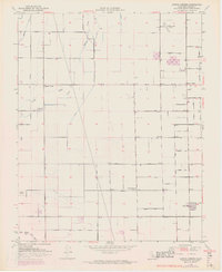
1950 Map of Cairns Corner
USGS Topo · Published 1971About this map
Agricultural development and rural water management define this Central Valley landscape, centered on the intersection of Tulare Lindsay Highway and the Strathmore Hwy. Small clusters of activity appear at named crossroads like Cairns Corner and Spinks Corner, while the settlement of Plainview marks the southeastern corner of the quadrangle. The terrain is crisscrossed by an organized grid of thoroughfares, from Cartmill Road to Ninth Ave, which serve the various fields and orchards of Tulare County.
Find a feature on this map
40 named features on this map. Tap any name to fly to it.
Don’t see what you’re looking for? This feature index may not catch every label — zoom into the map to look around manually.
Map Details
Editions of this 1950 Cairns Corner Map
3 editions found
Other maps of this area

1925 · Rocky Hill
USGS Topo · 1:31,680

1925 · Tulare
USGS Topo · 1:31,680

1925 · Tipton
USGS Topo · 1:31,680

1926 · Exeter
USGS Topo · 1:31,680

1927 · Cairns Corner
USGS Topo · 1:31,680

1927 · Rocky Hill
USGS Topo · 1:31,680

1927 · Visalia
USGS Topo · 1:31,680

1927 · Tulare
USGS Topo · 1:31,680

1928 · Tipton
USGS Topo · 1:31,680

1928 · Woodville
USGS Topo · 1:31,680