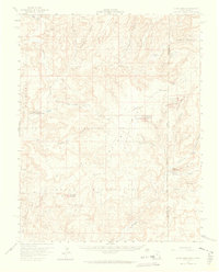
1958 Map of Cajon Mesa
USGS Topo · Published 1965About this map
Hovenweep National Monument preserves a complex archaeological landscape across the high desert of the Utah and Colorado borderlands. This 1950s survey documents numerous ancient sites including Square Tower Group Ruins, Cajon Group Ruins, and Holly Group Ruins tucked into the canyons. The mid-century economy of the area is represented by Hatch Trading Post and Ismay Trading Post, while the presence of the Hatch Trailer Sch provides a window into the remote educational infrastructure of the period. The terrain is characterized by a network of deep drainages such as Yellowjacket Canyon and McElmo Creek that cut through Cajon Mesa. These water sources, supplemented by scattered Artesian Wells, supported both the ancient inhabitants and more modern holdings like Perkins Ranch.
Find a feature on this map
54 named features on this map. Tap any name to fly to it.
Don’t see what you’re looking for? This feature index may not catch every label — zoom into the map to look around manually.
Map Details
Editions of this 1958 Cajon Mesa Map
3 editions found

Other maps of this area

1886 · Abajo
USGS Topo · 1:250,000

1892 · Abajo
USGS Topo · 1:250,000

1893 · Abajo
USGS Topo · 1:250,000

1955 · Verdure 3 SE
USGS Topo · 1:24,000

1955 · Verdure 4 SW
USGS Topo · 1:24,000

1956 · Cortez
USGS Topo · 1:250,000

1957 · Moqui NW
USGS Topo · 1:24,000

1957 · Aneth 1 NE
USGS Topo · 1:24,000

1957 · Cedar 3 SW
USGS Topo · 1:24,000

1957 · Aneth 1 NW
USGS Topo · 1:24,000