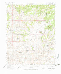
1958 Map of Cajon Mesa
USGS Topo · Published 1965About this map
Hovenweep National Monument anchors this 1950s survey of the high desert along the Utah-Colorado border, highlighting significant ancestral sites such as the Square Tower Group Ruins and Holly Group Ruins. The landscape is defined by the massive Cajon Mesa and McCracken Mesa, where remote outposts like Hatch Trading Post and the Hatch Trailer Sch provided essential services to the local community. The presence of numerous Oil Wells across the Navajo Indian Reservation reflects the mid-century energy exploration era, while traditional landmarks like Perkins Ranch and Ismay Trading Post indicate a long-standing ranching and trading presence. Geologic features such as McElmo Creek and Yellowjacket Canyon cut through the mesas, alongside isolated water sources like Tin Cup Spring and Cajon Lake.
Find a feature on this map
50 named features on this map. Tap any name to fly to it.
Don’t see what you’re looking for? This feature index may not catch every label — zoom into the map to look around manually.
Map Details
Editions of this 1958 Cajon Mesa Map
3 editions found

Other maps of this area

1886 · Abajo
USGS Topo · 1:250,000

1892 · Abajo
USGS Topo · 1:250,000

1893 · Abajo
USGS Topo · 1:250,000

1955 · Verdure 3 SE
USGS Topo · 1:24,000

1955 · Verdure 4 SW
USGS Topo · 1:24,000

1956 · Cortez
USGS Topo · 1:250,000

1957 · Moqui NW
USGS Topo · 1:24,000

1957 · Aneth 1 NE
USGS Topo · 1:24,000

1957 · Cedar 3 SW
USGS Topo · 1:24,000

1957 · Aneth 1 NW
USGS Topo · 1:24,000