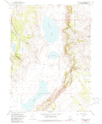
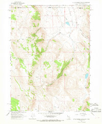
1966 Map of Calcutta Lake
USGS Topo · Published 1988About this map
Sheldon National Antelope Refuge dominates the eastern high ground of this high-desert landscape in Washoe County, where the topography drops sharply into the Long Valley (Depression). This north-south corridor contains a string of ephemeral basins including Calcutta Lake, Cow Lake, and Middle Lake. Human activity in the mid-1960s is represented by isolated outposts like Calcutta Ranch and Wimer Place, along with the Refuge Headquarters near the eastern margin. A notable Lookout Tower stands atop the ridges north of Bald Mountain, overlooking a network of springs and seeps such as Antelope Spring and MC Springs that sustain life in this arid basin-and-range environment. The map details a landscape managed for wildlife and light ranching, punctuated by the essential water sources that dictate movement through the valley.
Find a feature on this map
28 named features on this map. Tap any name to fly to it.
Don’t see what you’re looking for? This feature index may not catch every label — zoom into the map to look around manually.
Map Details
Editions of this 1966 Calcutta Lake Map
2 editions found
Other maps of this area

1889 · Long Valley
USGS Topo · 1:250,000

1954 · Vya
USGS Topo · 1:250,000

1958 · Vya
USGS Topo · 1:250,000

1962 · Vya
USGS Topo · 1:250,000

1966 · Bald Mountain
USGS Topo · 1:24,000
1966 · Rye Creek
USGS Topo · 1:24,000

1966 · Massacre Lake NW
USGS Topo · 1:24,000

1966 · Massacre Lake
USGS Topo · 1:24,000
1966 · Mosquito Valley
USGS Topo · 1:24,000
1966 · Little Coleman Canyon
USGS Topo · 1:24,000