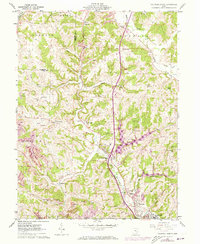
1961 Map of Caldwell North
USGS Topo · Published 1973About this map
Valley township and the surrounding Noble County landscape are defined by the winding course of the Penn Central railroad and a legacy of extraction. During this era of the early 1960s, the terrain is marked by numerous industrial signatures, including a claypit, kilns, and several strip mines that follow the contours of the hills. The map highlights a network of small, rural settlements like Belle Valley, Ava, and Hiramsburg, each connected by a web of local runs and forks such as Wolf Run and Lick Run. Genealogists will find significant value in the documentation of several family and church burial grounds, including McElroy Cem, Scott Cem, and St Michaels Cem. The inclusion of Wolf Run Lake and Caldwell Lake reflects the mid-century development of water resources alongside established landmarks like the Noble County Airport and the Buffalo Sch.
Find a feature on this map
54 named features on this map. Tap any name to fly to it.
Don’t see what you’re looking for? This feature index may not catch every label — zoom into the map to look around manually.
Map Details
Editions of this 1961 Caldwell North Map
3 editions found
Other maps of this area

1903 · Macksburg
USGS Topo · 1:62,500

1905 · Macksburg
USGS Topo · 1:62,500

1909 · Caldwell
USGS Topo · 1:62,500

1909 · Summerfield
USGS Topo · 1:62,500

1911 · Cumberland
USGS Topo · 1:62,500

1911 · Summerfield
USGS Topo · 1:62,500

1912 · Caldwell
USGS Topo · 1:62,500

1949 · Clarksburg
USGS Topo · 1:250,000

1956 · Clarksburg
USGS Topo · 1:250,000

1961 · Clarksburg
USGS Topo · 1:250,000