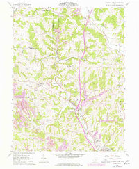
1961 Map of Caldwell North
USGS Topo · Published 1977About this map
The Valley of the West Fork Duck Creek serves as a primary corridor for both the Conrail line and local industry in this part of Noble County. During the early 1960s and into the mid-1970s, the landscape around Belle Valley and Coal Ridge was characterized by extensive Strip Mine operations, reflecting the region's heavy reliance on coal extraction. These excavations are shown alongside long-established rural landmarks like Halleys Ridge Cem and Clarks Chapel, illustrating the proximity of industrial activity to traditional community centers.
Find a feature on this map
41 named features on this map. Tap any name to fly to it.
Don’t see what you’re looking for? This feature index may not catch every label — zoom into the map to look around manually.
Map Details
Editions of this 1961 Caldwell North Map
3 editions found
Other maps of this area

1903 · Macksburg
USGS Topo · 1:62,500

1905 · Macksburg
USGS Topo · 1:62,500

1909 · Caldwell
USGS Topo · 1:62,500

1909 · Summerfield
USGS Topo · 1:62,500

1911 · Cumberland
USGS Topo · 1:62,500

1911 · Summerfield
USGS Topo · 1:62,500

1912 · Caldwell
USGS Topo · 1:62,500

1949 · Clarksburg
USGS Topo · 1:250,000

1956 · Clarksburg
USGS Topo · 1:250,000

1961 · Clarksburg
USGS Topo · 1:250,000